oUR pROPOSAL
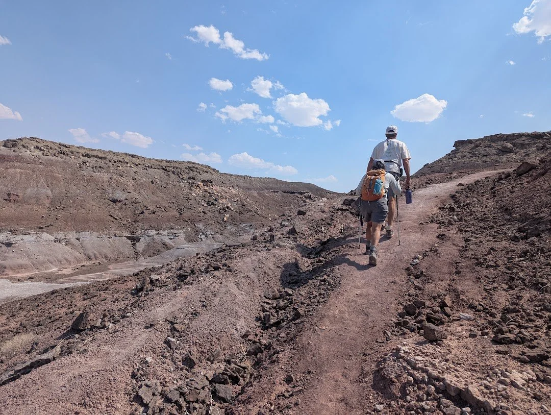
We propose a new national monument to protect this unique fossil resource and bring economic benefits to rural Utah communities.
If you’d like to really get into the weeds, read the full proposal below
(written by Dr. Jim Kirkland, with minor edits by Danny Anduza)
Utah is justifiably famous for its many Upper Jurassic dinosaur sites in the Morrison Formation (Foster, 2021, Kirkland et al., 2020), with the Carnegie Quarry at Dinosaur National Monument and the Cleveland-Lloyd Quarry at Jurassic National Monument considered to be its crown jewels. Research over the past 30 years has established that Utah has the most complete and best-dated dinosaur fossil record in the world (Kirkland et al., 2024). The Utah Geological Survey (UGS) is tasked with documenting these many discoveries through the UGS’s Paleontological Locality Database (Fig. 1). These discoveries have led to a gold rush of sorts, with more than half of all excavation permits on public lands being issued for sites in Utah as informally reported to UGS by the Bureau of Land Management (BLM)’s national lead, Dr. Scott Foss in 2000.
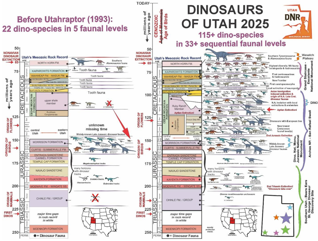
In particular, Utah’s Cretaceous dinosaur record is extraordinary (Fig.2), and the Upper Cretaceous is well managed at Grand Staircase – Escalante National Monument (GSENM). The work here vastly increased the known vertebrate fossil diversity from every substage of the Upper Cretaceous (Eaton and Kirkland, 2003; Gates et al., 2010). These initial Upper Cretaceous fossil discoveries in the Kaiparowits Basin were noted in the presidential proclamation establishing Grand Staircase–Escalante National Monument (Clinton, 1996). Initial funding under this banner led to an extraordinary wave of significant fossil discoveries by several institutions (e.g., Titus and Loewen, 2013; Titus et al., 2016). The UGS’ Paleontological Locality documents that with the establishment of GSENM, known vertebrate fossil localities increased from 86 to 4449 bone sites, and from 13 to 159 track sites, for a total 468% increase in known vertebrate paleontology localities in 28 years — a remarkable wealth of discovery by any standard! Over the same time interval, localities for the Cedar Mountain Formation rose from 42 fossil localities in 1996 to 583 localities currently — a 1388% increase in known fossil localities. At present, there are 462 vertebrate sites, 18 invertebrate sites, 78 paleobotanical sites and 35 trace fossil sites (mostly representing dinosaur tracks).
Figure 1. Dramatic explosion of new dinosaur discoveries in Utah over the past three decades as modified from Hunt-Foster et al. (2023).
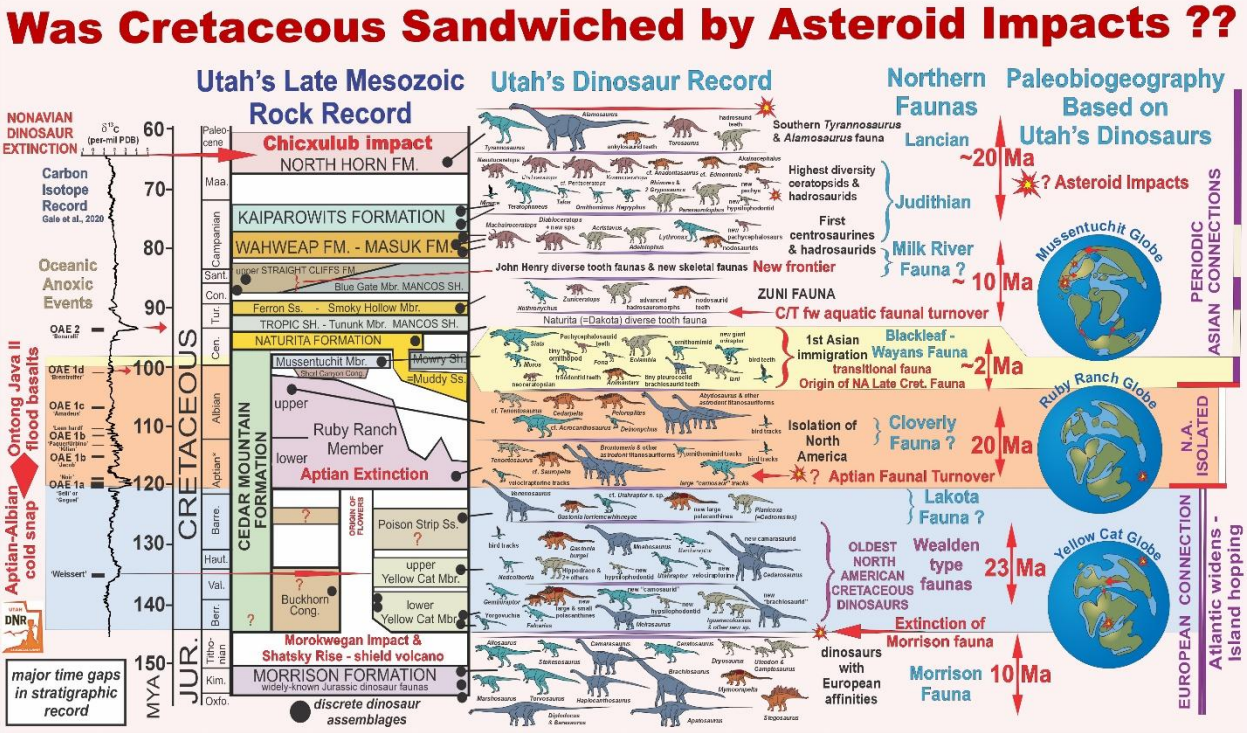
Figure 2. Late Mesozoic Dinosaurs of Utah. Note that data is plotted against a linear time scale. (updated after Kirkland et al., 2016).
Generally, the basal Cretaceous (at least across the Northern Hemisphere) is marked by an erosional gap in the terrestrial rock record, marking an interval of tectonic quiescence and low sea levels. Research on microfossils (ostracodes, charophytes, and palynomorphs), chemostratigraphy, and radiometric dating of paleosols in the Lower Cretaceous Yellow Cat Member of the Cedar Mountain Formation in the Paradox Basin of eastern Utah indicate that deposition in this region began much earlier than previously proposed, possibly near the beginning of the Cretaceous in the Berriasian stage (Joeckel et al., 2019, 2023). We have proposed that during the Early Cretaceous, salt tectonics resulted in local subsidence and deposition of the fossiliferous Yellow Cat Member across the northern Paradox Basin in eastern Utah (Kirkland, 2017; Kirkland et al., 2023). Wealden-type assemblages characterize the entire Yellow Cat Member and overlying Poison Strip Member of the Cedar Mountain Formation (Kirkland et al., 2016) through 5-7 discrete and non-overlapping faunal levels (Kirkland et al., 2016, 2024). The Yellow Cat Member in the Paradox Basin of eastern Utah is now divided into an upper and lower sequence based on distinct dinosaur faunas separated by a prominent calcrete or caprock (Figs. 2, 3) marking the lowest occurrence of carbonate in Cedar Mountain paleosols (Kirkland et al., 2016)
These dinosaur occurrences document the strong palaeogeographic ties between Europe and North America during the Late Jurassic and that similar Upper Jurassic dinosaur faunas spanned the last 10 million years of the Jurassic. The basal Cretaceous of eastern Utah preserves a succession of Wealden-type dinosaur assemblages dominated by styracosternid iguanodontians, polacanthine ankylosaurs, plus turiasaur sauropods and possibly European-derived brachiosaurid sauropods (both groups characterized by broad, spatulate teeth), large dromaeosaurines, and possible carcharodontosaurid allosauroids (Kirkland et al., 2016; Royo-Torres et al., 2017). This dinosaur fauna strongly contrasts with those of the Upper Jurassic, indicating a significant turnover among dinosaurs in North America and Europe across the J/K boundary (Mannion, 2024). The precise timing and causes of this faunal turnover interval are not yet known, but the Morokweng impact crater in northern South Africa and the flood basalts of the Shansky Rise in the western Pacific are worthy of investigation (Kirkland et al 2024; Kirkland and DeBlieux, 2024).
Another significant local faunal turnover occurs near the base of the overlying Ruby Ranch Member of the Cedar Mountain Formation, indicated by the sudden absence of the earlier styracosternids, polacanthines, sauropods, and large dromaeosaurines. Few Ruby Ranch Member dinosaur sites have been excavated in eastern Utah, as carbonate nodule debris makes the identification of sites difficult, and pedogenic carbonate may encrust bones making excavation and preparation of bones challenging. The lowest skeletal remains in the Ruby Ranch in the Paradox Basin are about 10 meters above the base of the section south of Green River, Utah. These fossils consist of a large nodosaurine ankylosaur and fragments of Tenontosaurus-like, basal iguanodontian taxa replacing the more derived styracosternid iguanodontians. Elsewhere in eastern Utah, sauropod remains in the Ruby Ranch are restricted to narrow-toothed titanosauriform sauropods, while theropod remains are rare (Kirkland et al., 2016).
The early Aptian faunal turnover among dinosaurs was more significant in North America than in other Northern Hemisphere localities. While polacanthine ankylosaurs were replaced by nodosaurine nodosaurids in North America, and by struthiosaurine nodosaurids in Europe, styracosternid iguanodontians continued to dominate the ornithischian herbivore component of assemblages in Europe (Kirkland et al., 2016; 2024). At this time, the extensive Ontong-Java flood basalts were erupting in the southeastern Pacific basin, correlative with hothouse conditions in the early Aptian followed by an intense late Aptian cooling event. It has been suggested that this massive volcanic center was triggered by an asteroid impact blowing through the thin ocean crust in this area. The base of the Aptian also marks the last evidence of faunal interchange with Europe, with North America largely isolated until the end of the Early Cretaceous (Kirkland et al., 2016, 2024; Kirkland, 2018).
While this portion of the Early Cretaceous is well developed in the Paradox Basin of Grand County Utah, the younger Lower Cretaceous is only preserved along the western side of the San Rafael Swell due to subsidence at the front of central Utah’s rising Sevier Mountains in Emery County, Utah (Fig. 4). In fact, it is remarkable how different the rock record is in these two areas, but together they represent 45 million years of geological and biological history that is largely unique to eastern Utah.
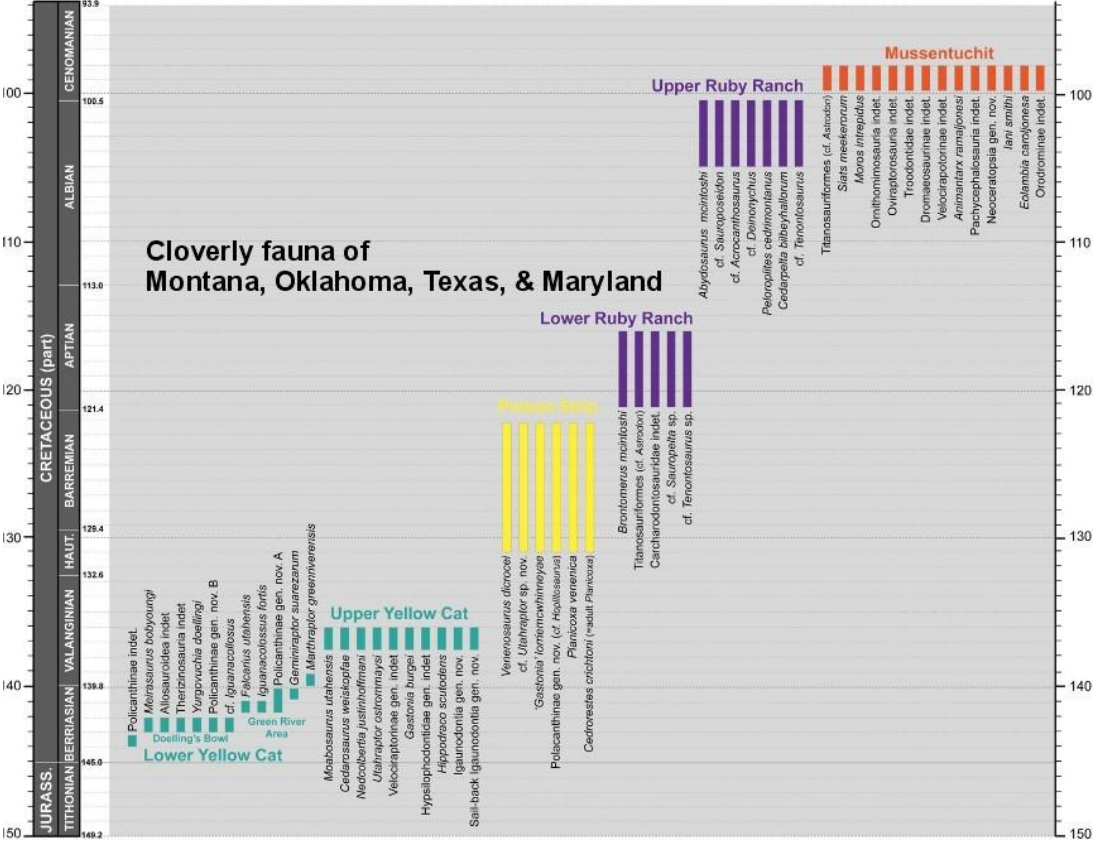
Figure 3. Temporal distribution of dinosaur taxa from the Cedar Mountain Formation, organized by approximate position within each member. Long bars do not represent stratigraphic ranges of each taxon but the range in possible age for these dinosaur faunas. Linear vertical scale in millions of years. Note: The Early Albian Cloverly fauna has yet to be recognized in Utah, although rocks representing that time interval are certainly represented. Modified after Kirkland et al. (2024)
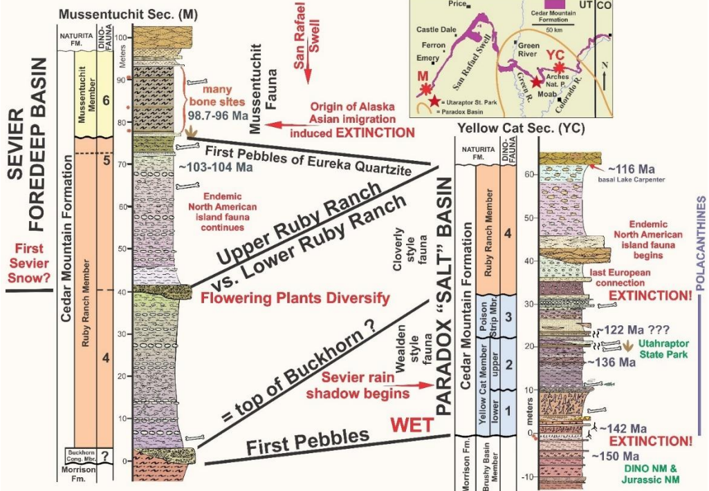
Figure 4. Contrasting Lower Cretaceous record preserved in the Paradox Basin of Grand County and west of the San Rafael Swell in the Sevier foredeep basin of Emery County, Utah
Strata dated to near the end of the Early Cretaceous at the top of the Ruby Ranch Member preserve a similar Cloverly-style dinosaur fauna with a number of distinct species including the giant nodosauroid ankylosaurs Peloroplites and Cedarpelta, huge sauropods similar to Sauroposeidon, and giant carnosaurs like Acrocanthosaurus. Very extensive bonebeds preserving these dinosaurs occur southeast of Price, Utah near the north end of the San Rafael Swell.
The Mussentuchit Member preserves one of the most diverse vertebrate assemblages in North America, based largely on microvertebrate faunas extracted through wet screen washing (Cifelli et al., 1997; Kirkland et al., 2016), with approximately 100 taxa currently identified, including 22 mammalian taxa (Eaton and Cifelli, 2001; Cifelli et al., 2016). Although diverse dinosaur teeth are present in abundance, dinosaur skeletal remains are still being excavated and described (Figure 5). By far the most abundant dinosaur is the hadrosauriform Eolambia caroljonesi (McDonald et al., 2012). A close relation to Asia’s Probactrosaurus, it was derived from interchange with Asia (Kirkland et al., 2016). Other dinosaur remains include a mix of taxa similar to those in the Cloverly-style assemblage: the giant carcharodontosaurid theropod Siats, large caenegnathid oviraptorosaurs, the basal iguanodontian Iani, slender-toothed titanosauriform sauropods, the nodosaurid Animantarx, and basal ceratopsids (Kirkland et al., 2016, 2023). In addition to Eolambia, dinosaurs possibly immigrating from Asia include the tyrannosauroid theropod Moros and possible pachycephalosaurs marking the first Asia-to-North-America immigration event (Cifelli et al., 1997; Kirkland et al., 2016). Highly resolved U-Pb ages, together with refined stratigraphic intervals for dinosaur taxa within the Mussentuchit Member, indicate that the immigration-induced extinction of North America’s endemic Aptian-Albian dinosaur faunas are preserved through this 2-million-year long sequence such that Utah dinosaurs calibrate the origins of Alaska. This 2020 talk recorded on YouTube provides a fairly up-to-date review on the still ongoing research on Utah’s Lower Cretaceous dinosaurs: https://www.youtube.com/watch?v=Thhb6Jy-Acw
Dawn of the Cretaceous Fossil Beds National Monument
While Utah’s Upper Cretaceous dinosaur record has been both promoted and protected by the establishment of Grand Staircase-Escalante National Monument, Utah’s unique (and much more extensive) Lower Cretaceous dinosaur record has begun to receive much deserved attention both locally and globally (Sadler, 2025) — yet despite its importance, these units have not enjoyed special protection. The Grand County area east of Arches National Park is nearly completely unprotected, as activity in the Moab region is more than enough to fully occupy the attention of federal and state land managers. Utah’s highly fossiliferous lower Cretaceous paleontological record is without question the most complete in the world, and consequently makes the Cedar Mountain Formation the most dinosaur-rich formation on the planet. In addition to its dinosaurs, the Cedar Mountain Formation provides a 45-million-year record of the complete terrestrial faunal and floral record — together with an outstanding record of the region’s paleoclimatic and geological history — that had long been assumed absent.
We propose that a National Park Service paleontology park be established along similar lines to the John Day Fossil Beds National Monument (abbreviated “JODA”) to protect, interpret, and provide a framework for ongoing research. JODA was developed as a network of separate park units (Fig. 5) which together incorporate an outstanding — and nearly complete — record of the Age of Mammals in eastern Oregon (Beckham with Lentz, 2000) (https://npshistory.com/publications/joda/index.htm).
As seen in JODA, separate highly fossiliferous areas would be assigned as specific park units organized under a coordinated management plan. For Dawn of the Cretaceous Fossil Beds, four potential paleontological “honey holes” have been identified as potential management units which would essentially encompass a virtually complete 45-million-year record of the Lower Cretaceous in eastern Utah. Such a paleontological park linked to eastern Utah’s rural communities would also provide an economic tourism boost for the region, while maintaining open lands for future economic development. It is also envisioned that the Prehistoric Museum (at Utah State University Eastern in Price, Utah) would serve as the scientific hub for the park, as it is already a federally-recognized repository for both archaeological and paleontological antiquities and is a primary NPS repository for fossil specimens from multiple national parks. Making the Prehistoric Museum the scientific hub would provide opportunities for student involvement as part of their training to become future scientists and land managers.
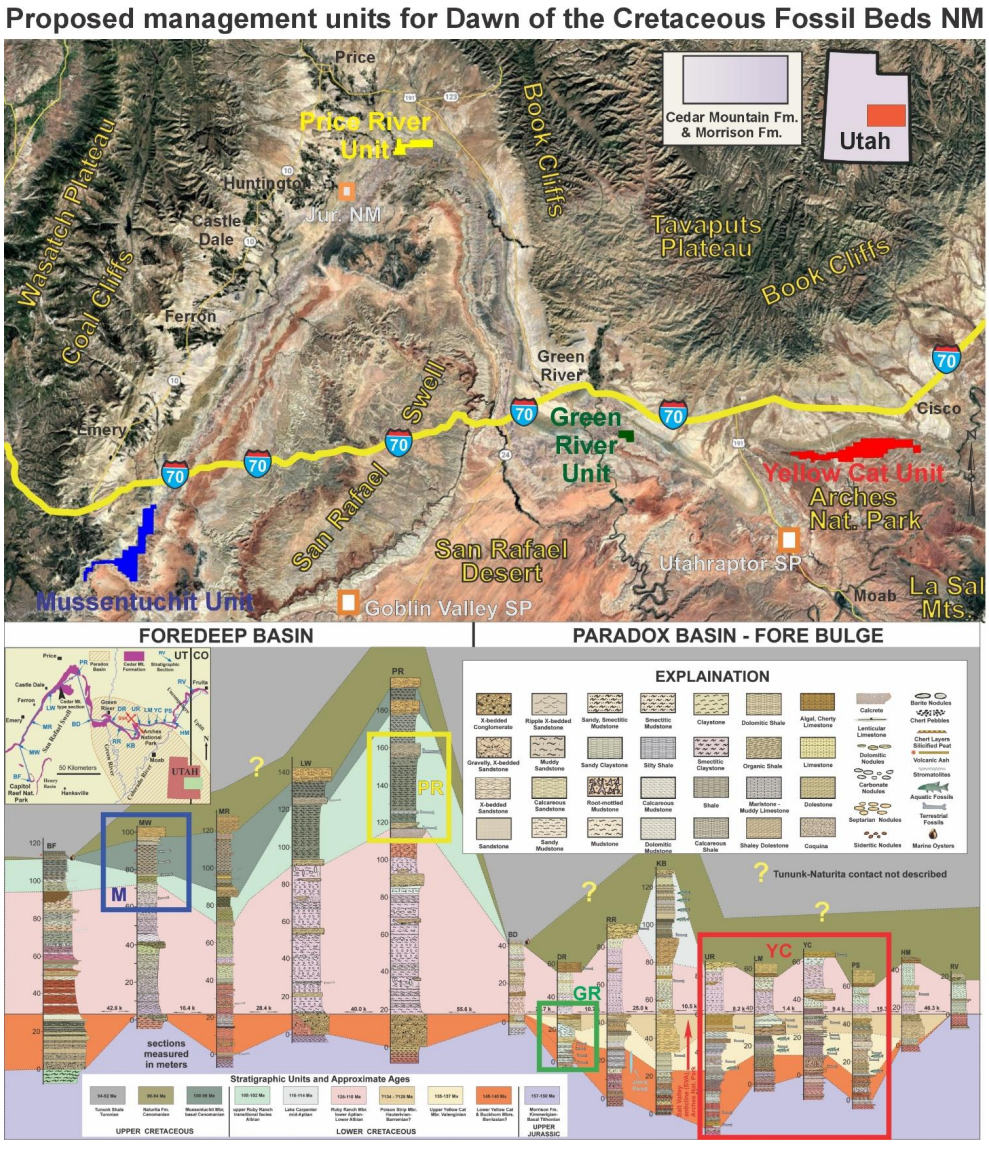
Figure 5. The aerial and stratigraphic limits of the four proposed management units. Red = Yellow Cat unit. Green = Green River unit. Yellow = Price River unit. Blue = Mussentuchit Unit.
The aerial extent of the four management units has been defined by the township and range system to the nearest quarter section to encompass the majority of the most critical paleontological resources. It is clear that important paleontological sites will be discovered in the future outside of these proposed boundaries. Additionally, other geographic and historic features outside of these boundaries may be deemed worthy of inclusion in the future. Furthermore, it may be considered more practical to define certain boundaries on geographic features more readily identified within the landscape. Thus, for this proposal it is acknowledged that if the concept of this proposal is accepted, there will likely be considerable negotiation as to the final boundaries of these proposed management units.
Yellow Cat Unit
As the largest proposed management unit, the Yellow Cat unit includes the most paleontological sites spanning the greatest interval of time. As currently proposed, it encompassed 24.25 square miles or 15,520 acres (Fig. 6). The extraordinary sites preserved here are indeed what led to this proposal being conceived. This exceptional paleontological resource (Figs 6-17) would certainly be considered worthy of national-park-level protection in most parts of the world.
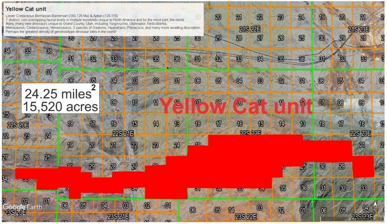
Figure 6. Geographic area of the Yellow Cat unit superimposed onto townships and ranges.
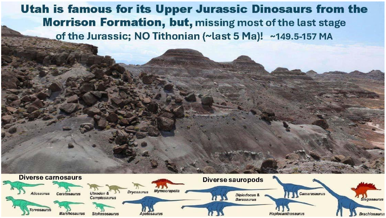
Figure 7. Spectacular exposures of the Upper Jurassic Morrison Formation underlie the Cedar Mountain Formation along the south side of the Yellow Cat unit. This is the Mollies Hogans Area.
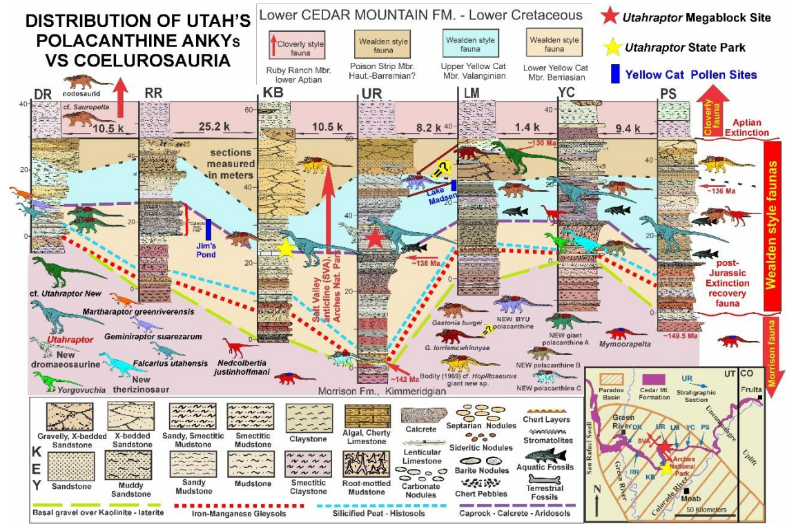
Figure 8. The fossil record being uncovered in the Yellow Cat unit is truly extraordinary. This shows the distribution of only two dinosaur groups: the dromaeosaurs (“raptors”) and the armored ankylosaurs. One newly-discovered species of ankylosaur discovered by BYU is not even on this chart yet! The lines in basal Yellowcat outline fossil soil horizons which indicate that the beginning of the Cretaceous was temporarily very wet in Utah — perhaps the result of an asteroid impact or intense volcanic activity. This is apparently the only place this lowermost Cretaceous record exists anywhere on Earth.
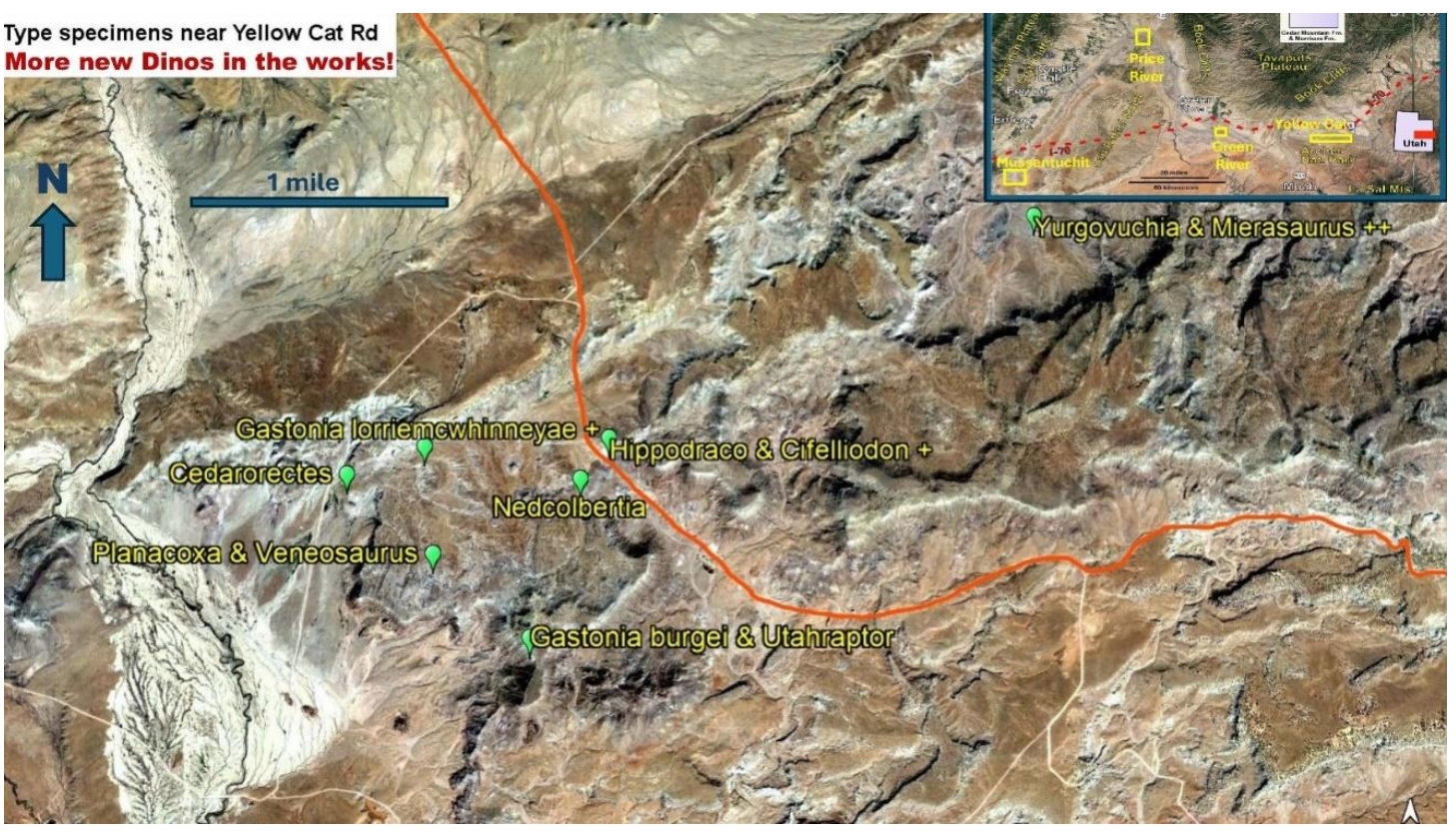
Figure 9. In a five-mile stretch crossing the Yellow Cat Road there are currently 10 genoholotype dinosaur sites distributed in four laterally extensive multigeneric bonebeds. There are numerous other new species from this area in Utah Paleontolocal labs still waiting to be described, as indicated by + symbols.
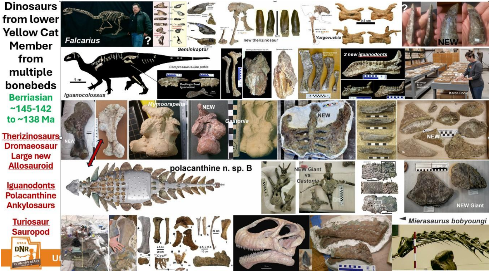
Figure 10. The lower Yellow Cat represents a stack of fossil soils and associated bonebeds representing at least 4 sequential nonoverlapping dinosaur faunas from the Yellow Cat and Green River management units.
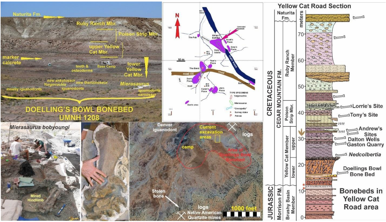
Figure 11. The Doelling’s Bowl bonebed is the oldest Cretaceous multigeneric dinosaur bonebed in North America and possibly the oldest in the world. This extensive, shallowly-buried dinosaur site records the recovery from the dinosaur mass extinction at the end of the Jurassic. Our team is currently seeking permits to begin excavations at a newly discovered bonebed in the ferruginous paleosol at the very base of the Yellow Cat ~8 miles to the east
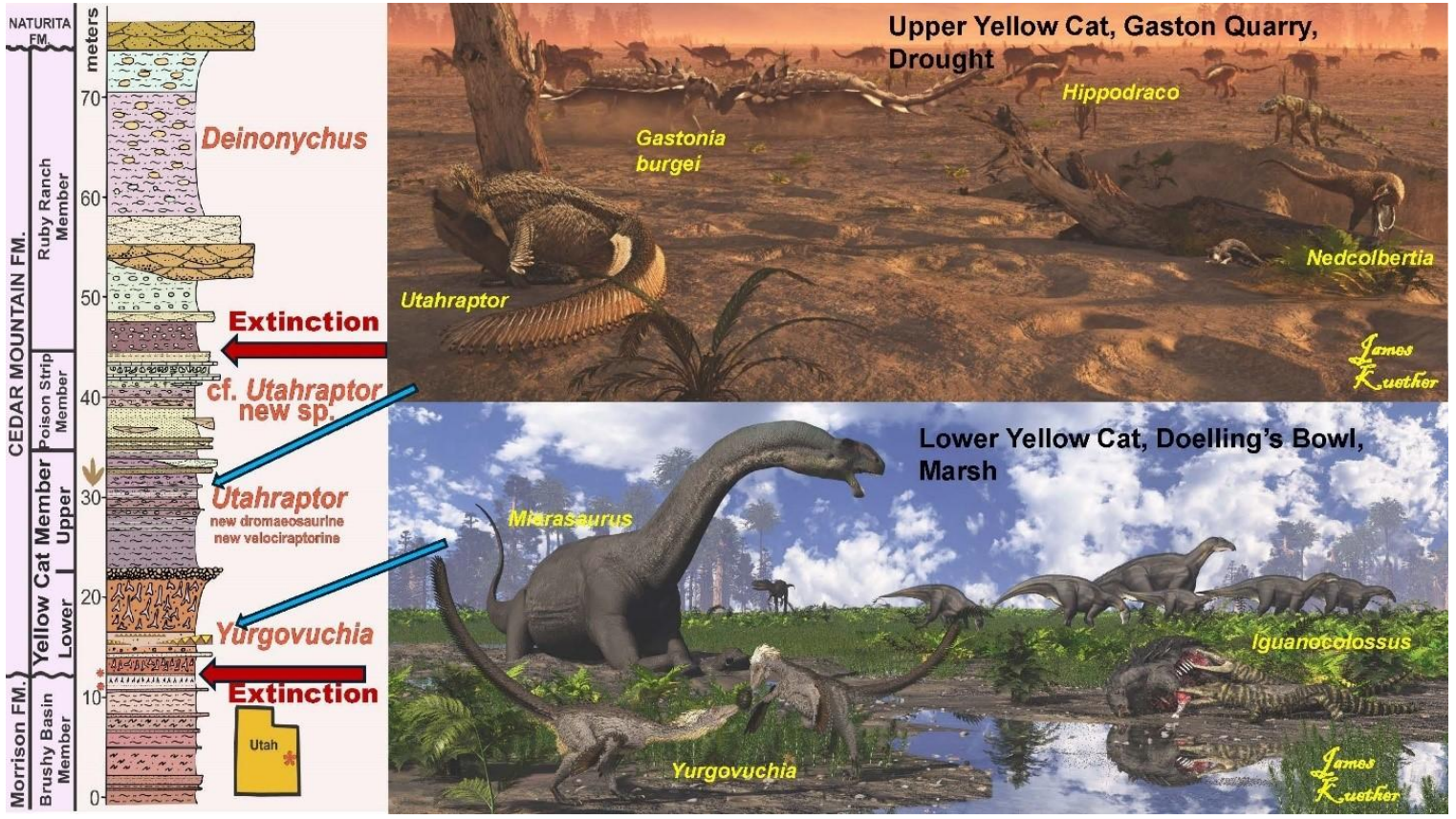
Figure 12. Although similar dinosaurs are represented in the lower and upper Yellow Cat Member, different faunal levels were populated by different species. From Sadler (2025)
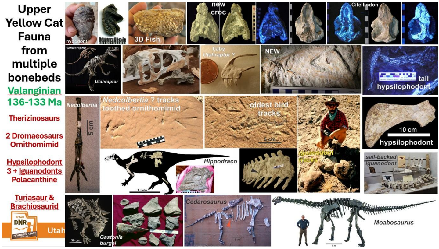
Figure 13. Some of the diverse fossils recovered from the various bonebeds in the upper Yellow Cat Member. Although “only” representing two dinosaur faunas, extraordinary bonebeds with distinct ecological signatures are found across the length of the Yellow Cat management unit. These well-dated faunas promise to reveal the complete ecosystem living in eastern Utah 134-136 million years ago.
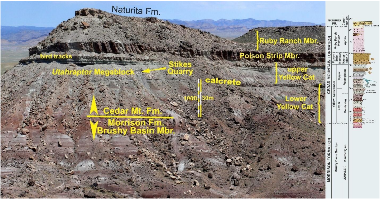
Figure 14. Looking north toward Utahraptor Ridge on the east end of the Yellow Cat Unit. In addition to the spectacular Utahraptor block, the overlying bird tracks may represent the oldest bird footprints in the world. Additionally, at the bird track level but about a quarter mile to the west, Brigham Young University has recently discovered a major new multigeneric bonebed which extends for more than 100 meters laterally, with at least two new dinosaur species found so far. This has the potential to be a major interpretive site. Prehistoric Museum’s new basal Cedar Mt. bonebed is about 1 mile east from there.
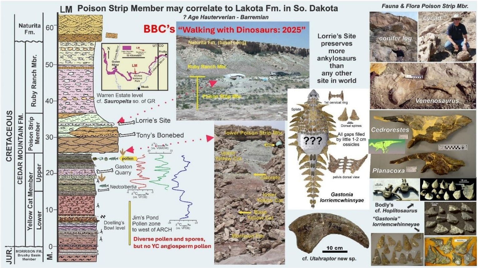
Figure 15. The overlying Poison Strip Member reflects an interval of time with extensive river systems; it also includes many extensive bonebeds. Lorrie’s Site extends for 150 meters and is the greatest accumulation of armored dinosaurs in the world. Exploration of these beds is only just beginning, but clearly they hold great promise as suggested by new discoveries to the east.
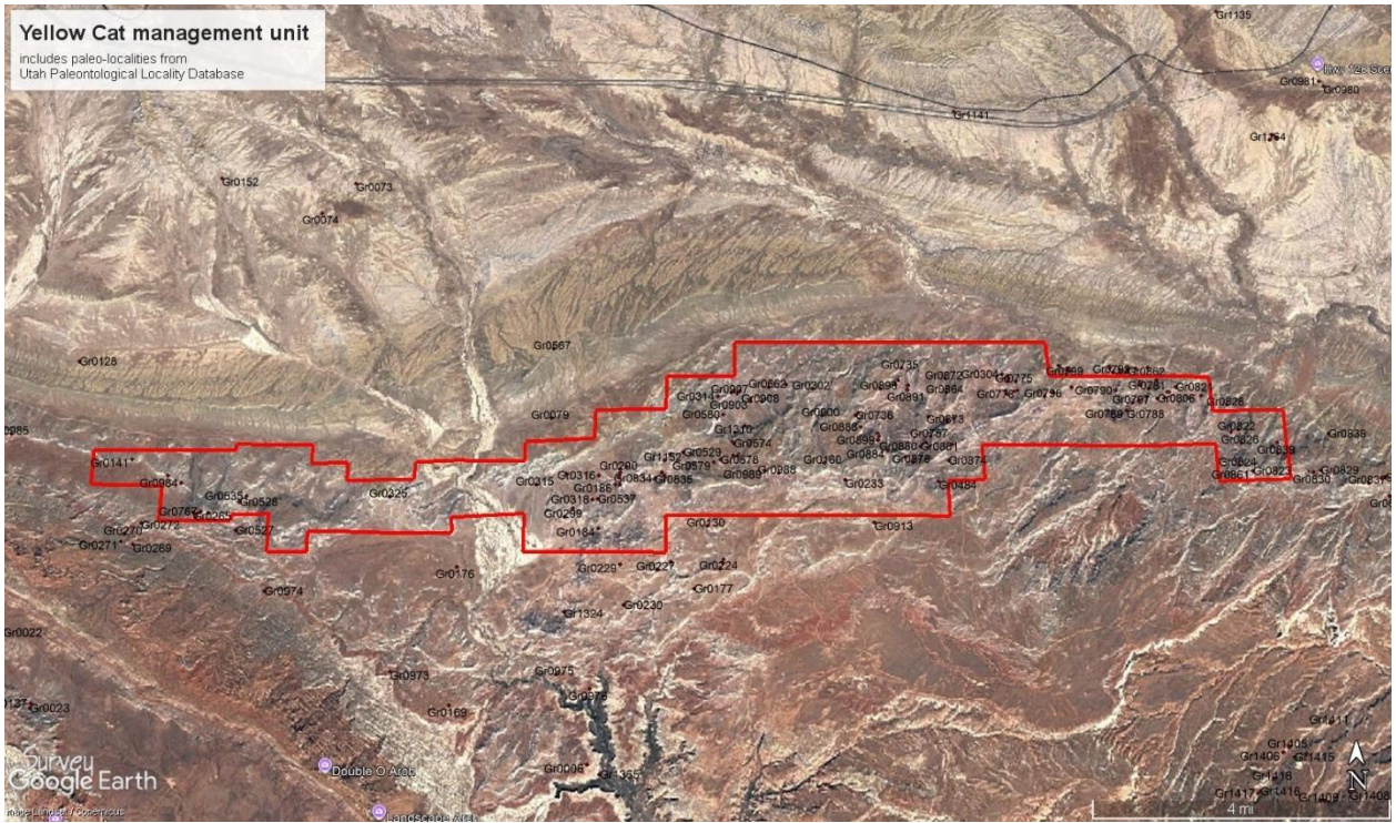
Figure 16. Geographic area of the proposed Yellow Cat unit with paleontological sites from UGS paleo-locality database superimposed.
The Yellow Cat unit represents an extraordinary opportunity to learn about the recovery of North America’s dinosaur following the catastrophic extinction of Utah’s beloved Morrison dinosaur fauna. Interpretative opportunities abound within this unit and in nearby areas. The Yellow Cat Mining District to the south presents opportunities to interpret Utah’s uranium mining boom years of the 1950s-60s. Although all these mines have been closed in recent years for safety reasons, care has been taken to leave the surface mine features intact as fascinating cultural artifacts. From the south side of the Yellow Cat unit, a well-developed BLM road extends south past natural arches to the north rim of Professor Valley, with spectacular views of the Colorado River Canyon and the La Sal Mountains further to the south. Camping and off-road exploration opportunities abound here. To those who know, it is amazing to consider that this resplendent vista remains completely unknown to motorists travelling along Highway 70 to the north (Fig. 15).
In addition to exhibits of dinosaurs from this area at the Prehistoric Museum in Price, Utah — which already houses many of the dinosaur type specimens unique to this management unit — the John Wesley Powell River History Museum in Green River would provide a site for further interpretation. In-situ exhibits, interpretive trails, and camping opportunities would provide ample reason for the public to pay fees to visit the area. An abandoned well pad on the east side of the Yellow Cat Road would offer an excellent location for a standalone visitor center. Overlooking the escarpment above the Morrison Formation, such a visitor center would be ideally situated to connect potential interpretive trails to sites throughout the Yellow Cat unit.
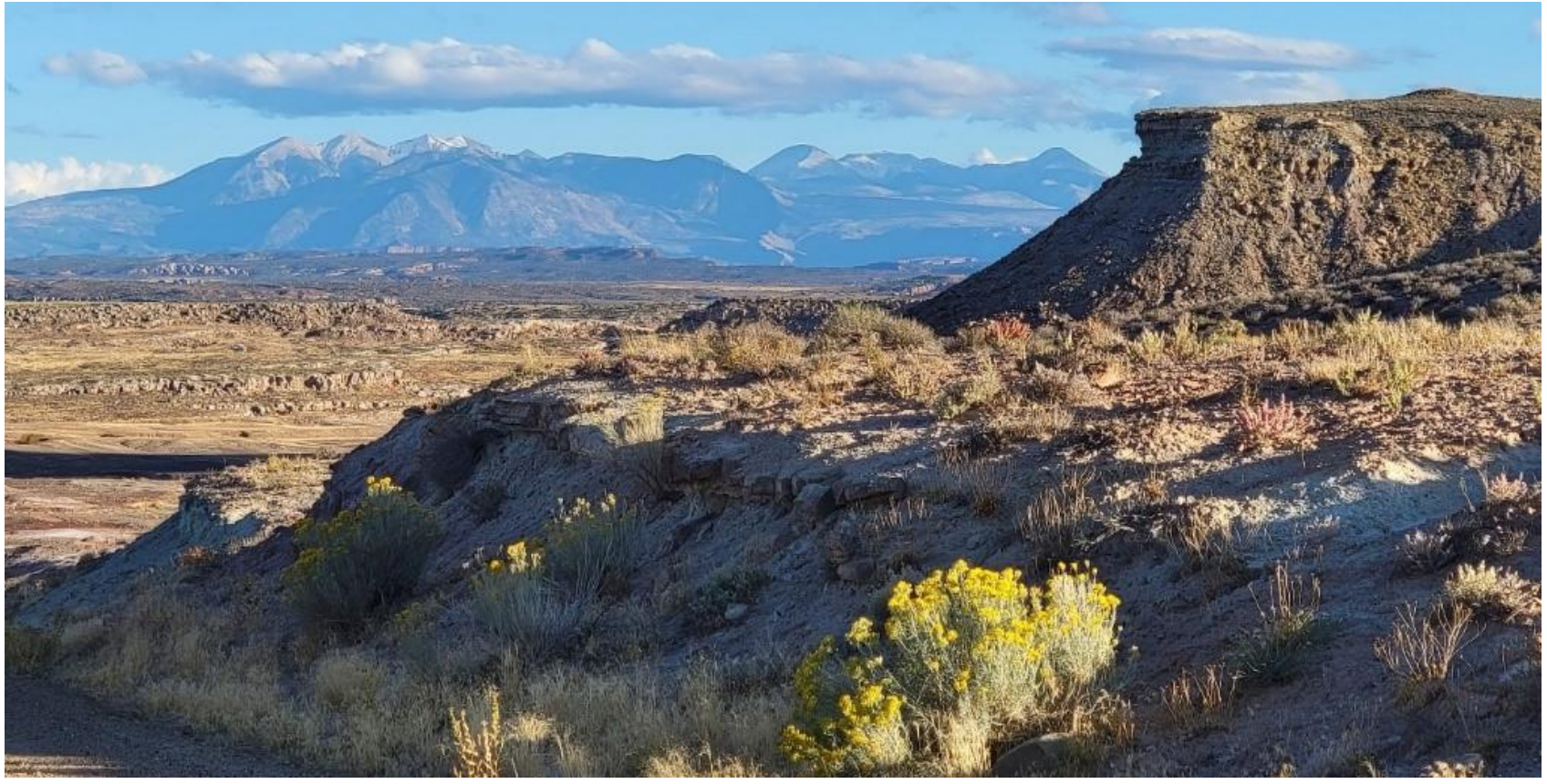
Figure 17. View south to the La Sal Mountains from the Poison Strip escarpment on the Yellow Cat Road.
Green River Unit
The Green River unit is the smallest of the proposed management units. While it was tempting to extend the Yellow Cat unit west across US Highway 191 to encompass the unique sites present here, we are sensitive to economic considerations; we feel that extensive oil and gas infrastructure development between these fossiliferous areas provide enough reason to separate them. Our proposed Green River unit encompasses 2.52 miles or 1600 acres (Fig. 19) on the western side of the Paradox Basin, where the Yellow Cat strata thin as they overlap the eastern San Rafael Swell. As of 2026, there are three institutions from across the nation actively conducting research excavations within the Green River Unit. Several unique and extensive localities are present in the lower Yellow Cat Member (Fig. 20, 21) which are interpreted to represent dinosaur faunal levels somewhat younger than those of Doellings Bowl (Fig. 2), but still clearly older that those in the upper Yellow Cat and it has be hypothesized that with these sites included, it is proposed that the northern Paradox Basin of Grand County preserves the six oldest Cretaceous dinosaur faunas in North America. Such hallmark dinosaurs as Utahraptor, Gastonia, Falcarius, Iguanacolossus, and Moabosaurus will never be found anywhere else. Poaching has been a major issue here; when discovered, it was noted that most of these sites had suffered extensive illegal excavation.
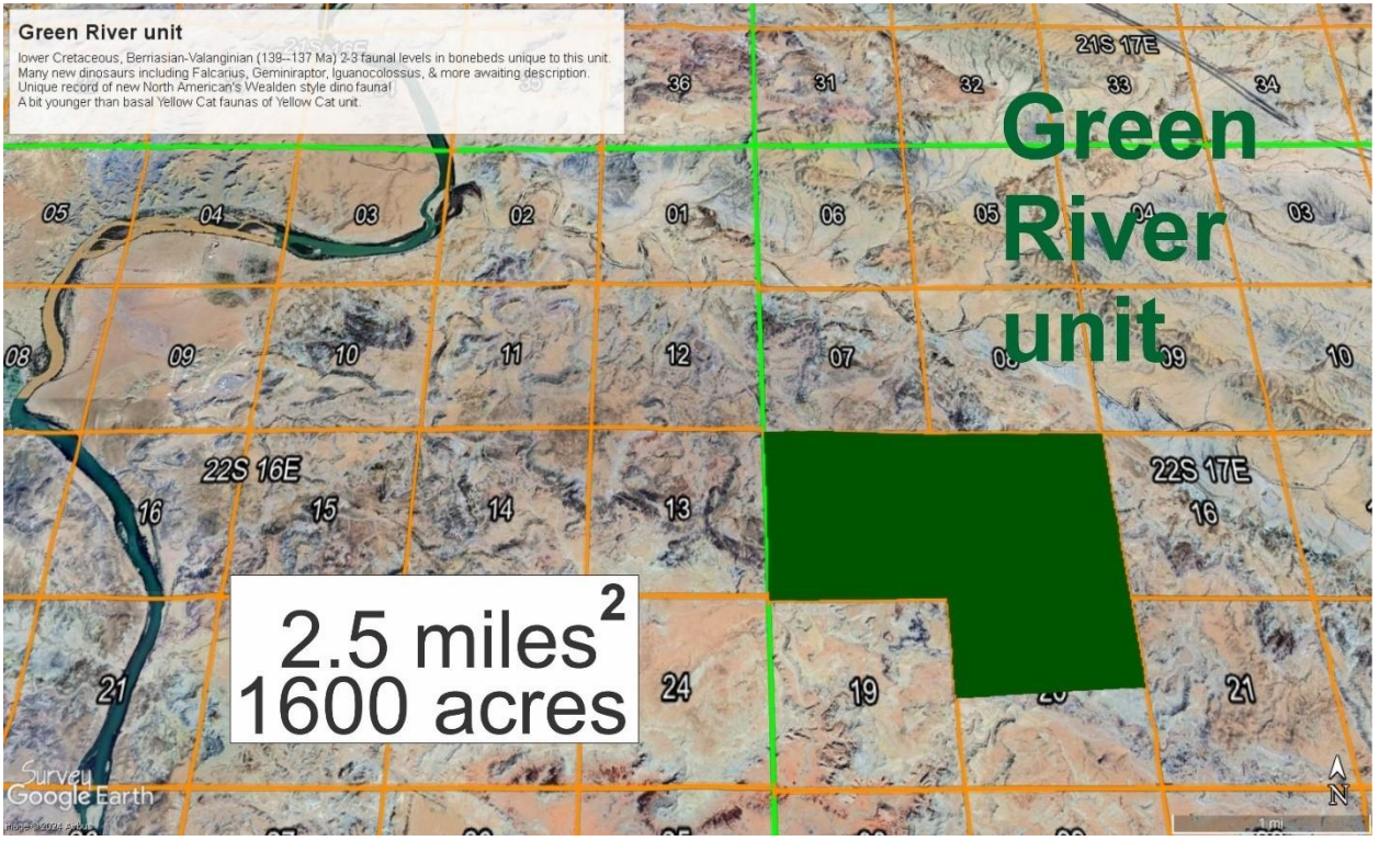
Figure 18. Geographic area of the Green River unit superimposed onto townships and ranges.
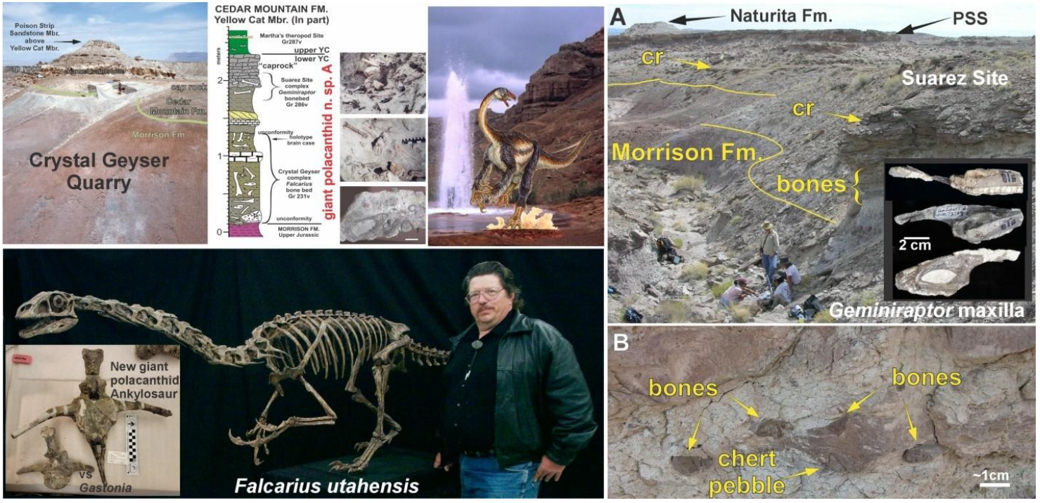
Figure 19. Major sites in the eastern half of the Green River unit. In a half mile stretch there are 3 genera of the plant-eating “raptor” group (therizinosaurids) described. From oldest to youngest: Falcarius, Geminiraptor, and Martharaptor. Both the Crystal Geyser and the Suarez sites are bonebeds containing tens of thousands of bones which are still being actively excavated. In 2007, The Science Channel produced a fine documentary on the Crystal Geyser Falcarius discovery (linked here): https://www.youtube.com/watch?v=uJ918JXmzts
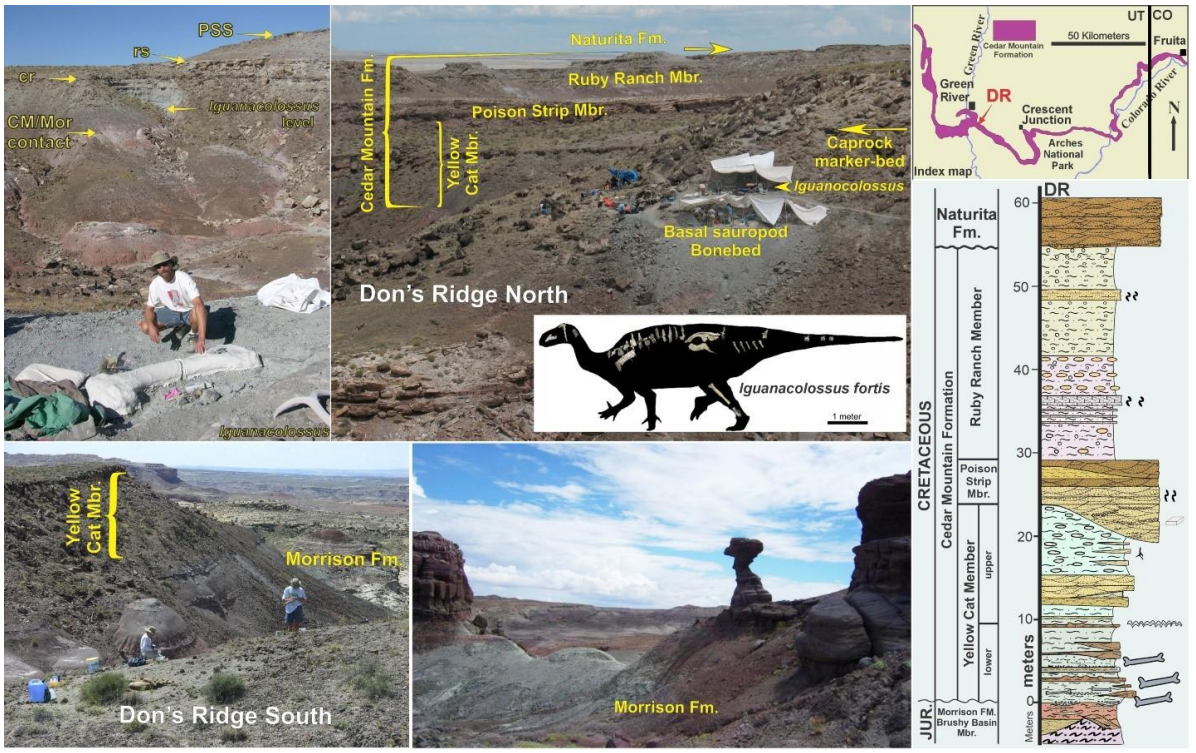
Figure 20. Don’s Ridge was found about 2 miles to the west of the Crystal Geyser Quarry. At the outset, 11 individual sites were found around the margin of the ridge. The base of the Cretaceous is marked by a cobble conglomerate filled with broken and complete sauropod bones which extends from one side of the ridge clear across to the other. A few meters higher, much more complete dinosaurs were found — of which only Iguanacolossus has been described. These sites are surrounded by spectacularly colorful Morrison Badlands, and as yet have not been developed to anywhere near their potential.
The dinosaur sites in the Green River unit (Fig. 22) represent a distinct faunal level known nowhere else. When first reported, Grand County investigated the potential for building a road to the locality to serve as an interpretive site. Later, a trail bike track was built right across the east side of the unexcavated Crystal Geyser bonebed. Nearby interpretive opportunities include Crystal Geyser, which is already a popular tourist attraction and put-in site for rating trips on the Green River (and we would like to emphasize that this particular spot is in desperate need of a vault toilet, as the piles of human waste will attest). West of the Green River, the Bureau of Land Management has developed an interpretive site at the heavily vandalized Fossil Point Morrison bonebed with the encouragement of the City of Green River and the support of the Utah Geological Survey. Offroading opportunities abound here, and we believe all this can coexist with oil and gas development opportunities in the area. In addition to exhibits of dinosaurs from this area at the Prehistoric Museum in Price, the John Wesley Powell River History Museum in Green River would provide a site for further interpretation of this nearby paleontological area.
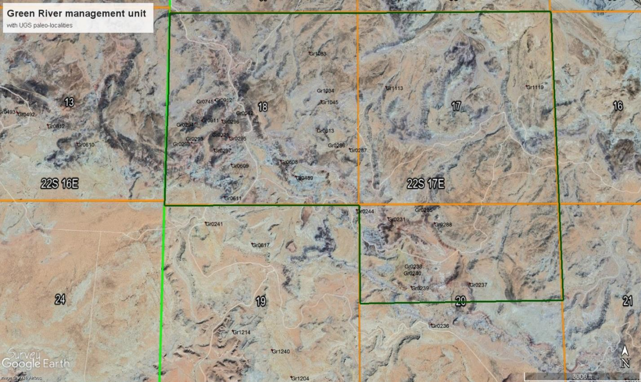
Figure 21. Geographic area of the proposed Green River unit with paleontological sites from UGS paleolocality database superimposed.
Price River Unit
The Price River unit is also relatively small (5.5 square miles / 3520 acres) and is largely set up to preserve a unique series of fossils in the upper Ruby Ranch Member of the Cedar Mountain Formation, roughly dated as Upper Albian at ~105 to 102 million years ago. These localities lie near the top of formation on the north end of the San Rafael Swell (Fig. 23- 26). The similar but better-studied Cloverly faunal sites of Montana, Oklahoma, Texas, and Maryland are older, approximately at 112 to 107 Ma (lower Albian). The huge ankylosaurs from the sites in the Price River unit are well-preserved and are distinct from the large ankylosaur Sauropelta from the Cloverly Formation of Montana. In fact, the world’s only known examples of the giant ankylosaurs Peloroplites and Cedarpelta both hail from these sites, and are reposited in the Prehistoric Museum in Price. Large sauropods (similar to Sauroposeidon from Oklahoma) and a huge carnosaur (similar to Acrocanthosaurus) are present here, but are very likely new taxa — as dinosaur species have been shown to turn over at least every couple of million years when well-dated — and these sites are about 10 million years younger. Careful comparative taxonomic studies still must be carried out to see if it is possible that these lineages are exceptions to this tentative “rule.” A single new locality at Dinosaur National Monument is similar in age, but otherwise this huge complex of sites is also unique in North America. Several localities (e.g. PR-2, PR2-3, CEM sites) have been found on either side of a large east-to-west drainage extending to the Price River, and are now thought to be part of an extensive bonebed stretching over one half mile. Other, more isolated dinosaur sites appear to be present at this level throughout this area. A partial skeleton of primitive, bipedal ornithopod Tenontosaurus at the PR-1 Site is from an overlying sandstone bed near the Price River and was the first discovery leading to more focused explorations in the area. Recent flooding has taken out the road into the major bonebed and heavy equipment will be required to gain access to these sites in the future.
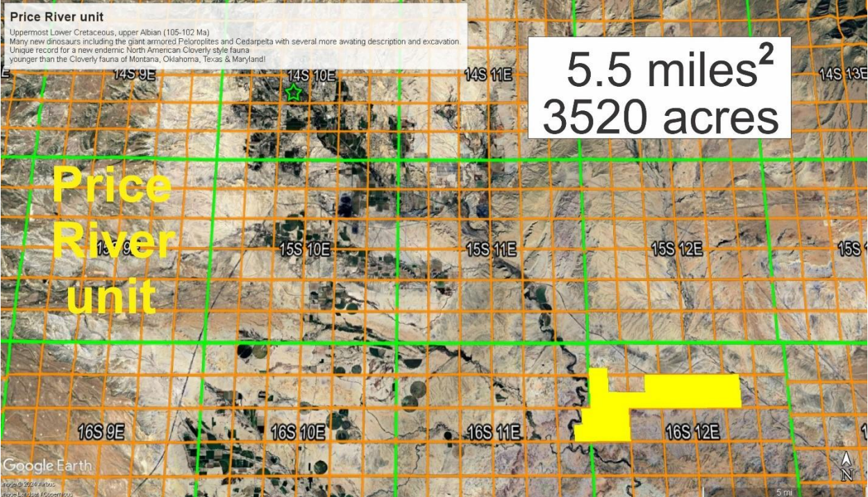
Figure 22. Geographic area of the Price River unit superimposed onto townships and ranges. Green star marks location of the USU Eastern’s Prehistoric Museum
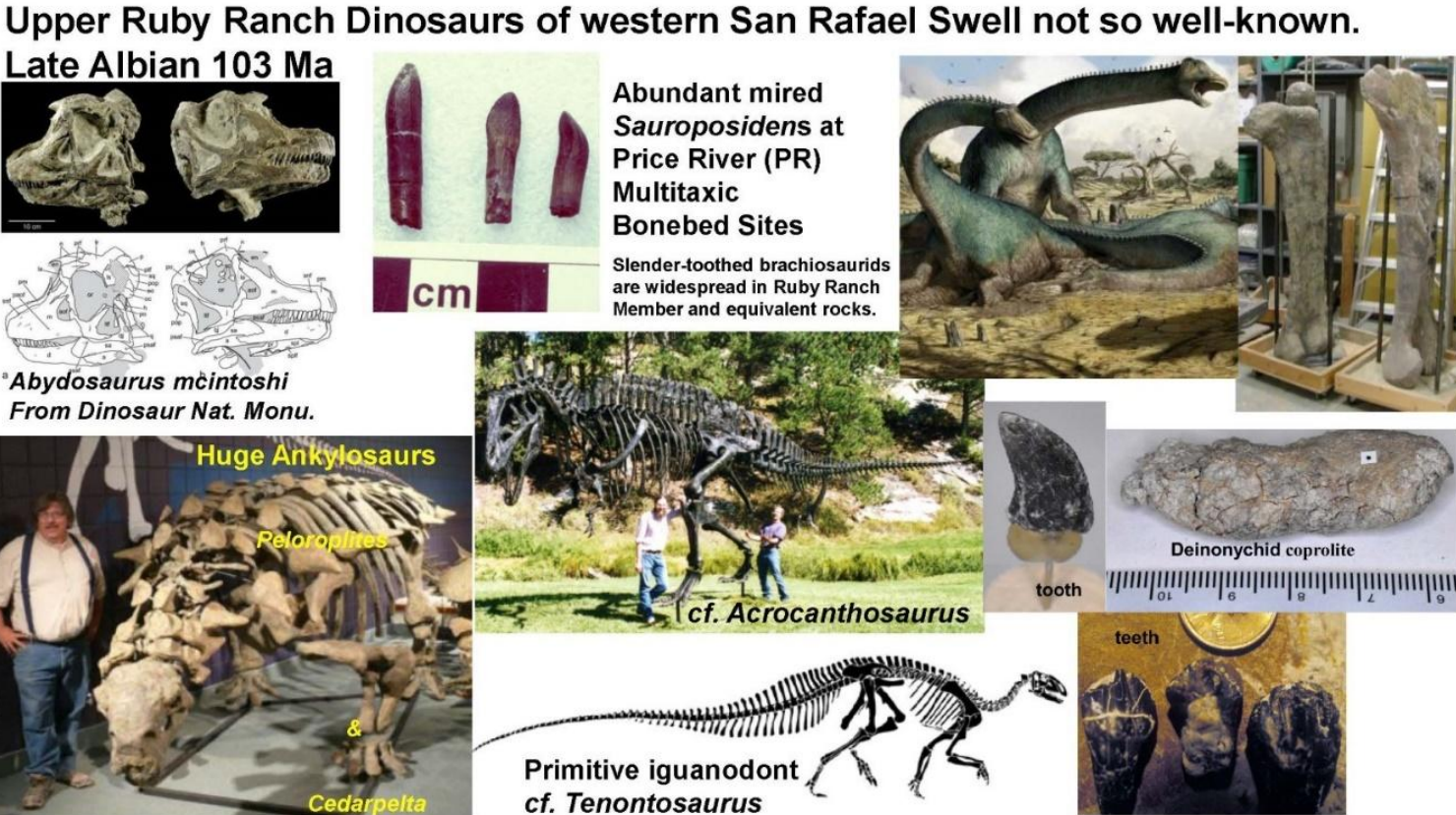
Figure 23. Some of the dinosaur remains characteristic of the upper Ruby Ranch Member.
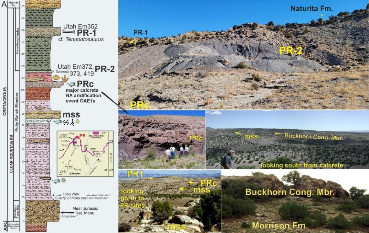
Figure 24. The Cedar Mountain Formation as exposed in the Price River area on the north end of the San Rafael Swell. This particularly thick section of the Lower Cretaceous has been the subject of a number of important geological and stable isotope/geochemistry studies examining the paleoclimate and testing the possibility for correlating shifts in paleoatmospheric carbon isotopes ratios as a tool to correlate rocks in this time interval globally (e.g. Ludvigson et al., 2010, 2015).
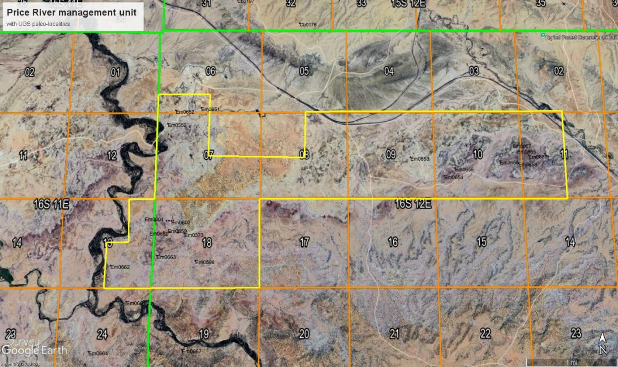
Figure 25. Geographic area of the proposed Price River unit with paleontological sites from UGS paleo-locality database superimposed
The Prehistoric Museum in Price has been the sole repository for all material from the Price River localities. Their close proximity to Price meant that most museum personnel could commute to these excavation sites directly from their homes. The Prehistoric Museum also ran numerous digs with volunteers from the public on these important localities. The continued interpretation of these dinosaur sites and the utilization of these extraordinary resources in education at Utah State University Eastern would be a logical part of this management unit when established.
Mussentuchit unit
The fossils of the Mussentuchit Member of the Cedar Mountain Formation are spectacular, both for their extraordinary diversity and in their pristine preservation. While the Mussentuchit preserves the complete fauna and flora at the very base of the Upper Cretaceous, and would be considered extraordinarily important by this virtue alone, it also represents a critically important episode in the biogeography of the region: an interval of immigration-inducted extinctions took place at this time, set off by the opening of a land bridge to Asia following the small continental collision forming Alaska at the Cretaceous north pole (Kirkland et al, 2016). As a conservative estimate of the most critical badlands to include in this management unit, we propose an area of 19.93752 miles, or 12,400 acres (Fig. 27, 28). Numerous volcanic ashes within this unit permit it to be accurately dated as only spanning a couple of million years, from approximately 99.5-97.5 Ma. Roughly 30 years ago, these rocks were assumed to represent the uppermost Early Cretaceous, but biostratigraphic correlations with the Cretaceous type areas in Europe have revealed that the Mussentuchit badlands actually record the beginning of the Late Cretaceous. Only in the last few years has this been widely accepted, but this discovery holds within it a certain elegance: many of the animals who crop up in Mussentuchit rocks (such as tyrannosaurs and ceratopsids), would go on to dominate North American faunas until the terminal extinction event (Cifelli et al. 1997).
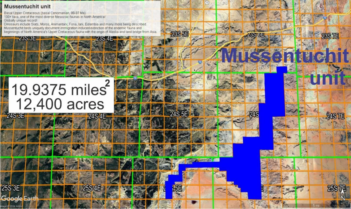
Figure 26. Geographic area of the Mussentuchit unit superimposed onto Townships and Ranges.
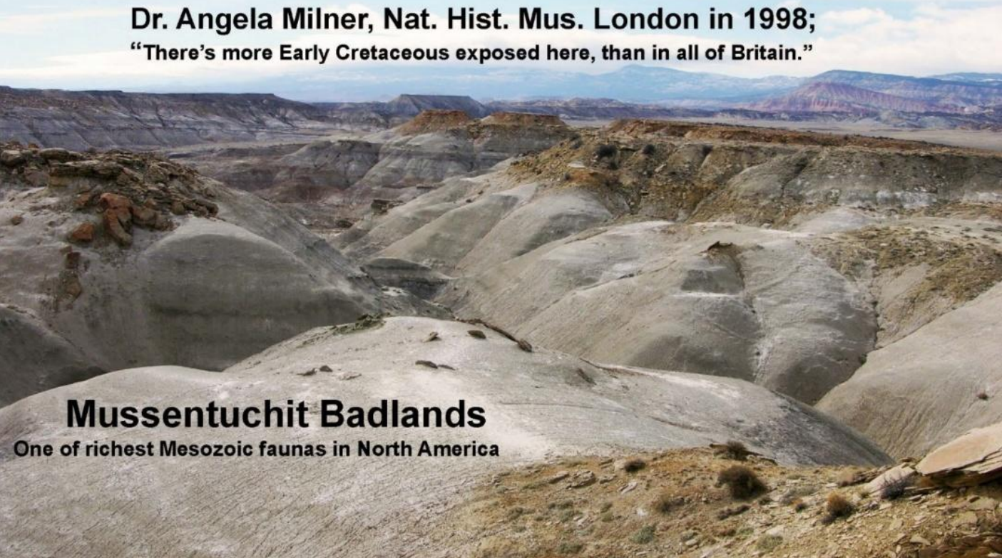
Figure 27. The Mussentuchit badlands are so rugged that there is essentially no sign of off-roaders venturing into this area, and paleontologists must hike in and out of the area from the rim much as they do at the (stratigraphically much younger) Dinosaur Provincial Park in Alberta
Initial paleontological research into the Mussentuchit Badlands was conducted by Rich Cifelli and his team from the Oklahoma Museum of Natural History (OMNH), who undertook laborious wet screenwashing in the quest for Cretaceous mammals and other microvertebrates. Over many years, they processed as much as 100 tons of rock through screen boxes, yielding a wealth of teeth and jaws of tiny vertebrates. A great diversity of dinosaurs, birds, mammals, lizards, snakes, salamanders, frogs, freshwater sharks, and bony fish were recovered in this way, with 22 mammal species described among the bounty (Fig. 29, 30). During all this, OMNH mostly avoided the beautifully preserved dinosaur skeletons which abound in the Mussentuchit region.
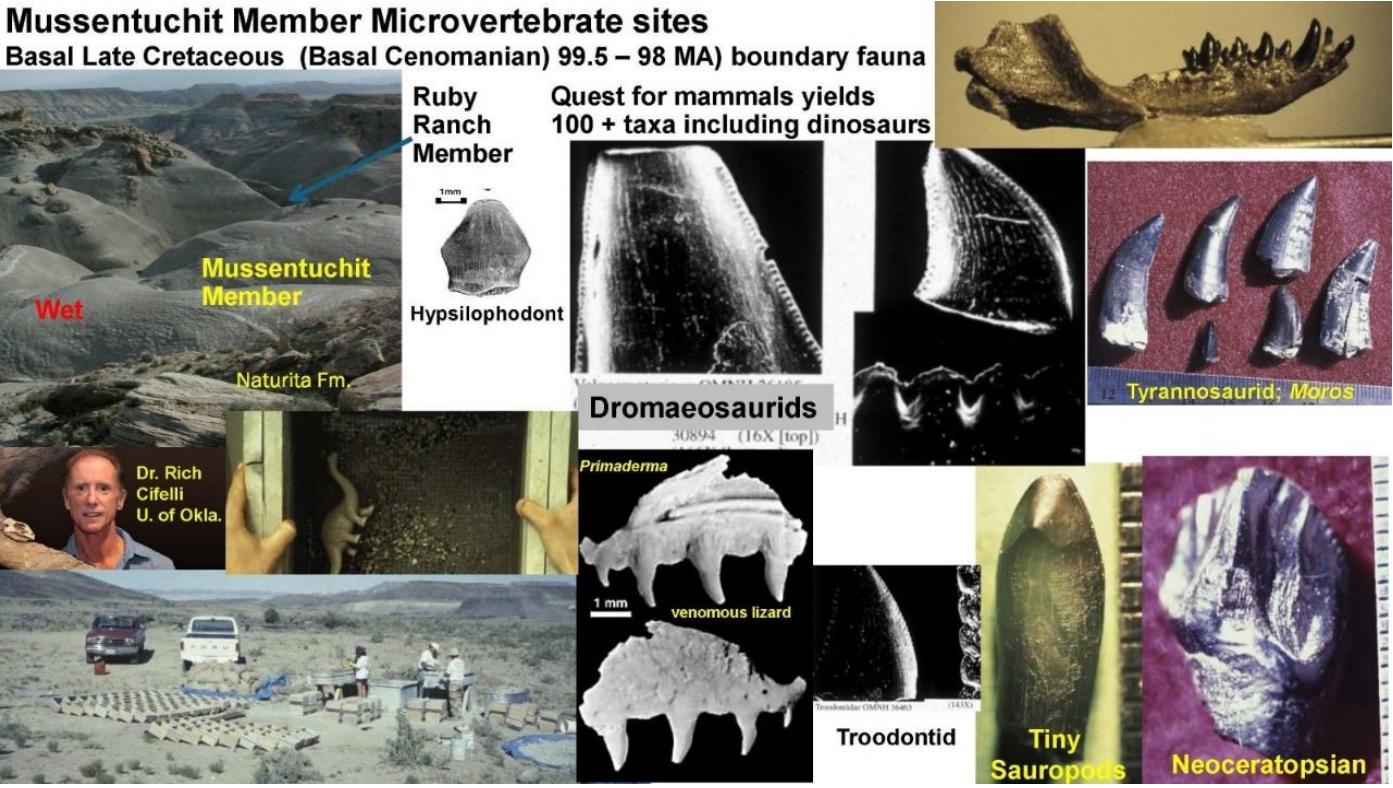
Figure 28. A few examples of the early results from the Oklahoma Museum of Natural History’s extensive screenwashing operation in the Mussentuchit Badlands during the 1990s.
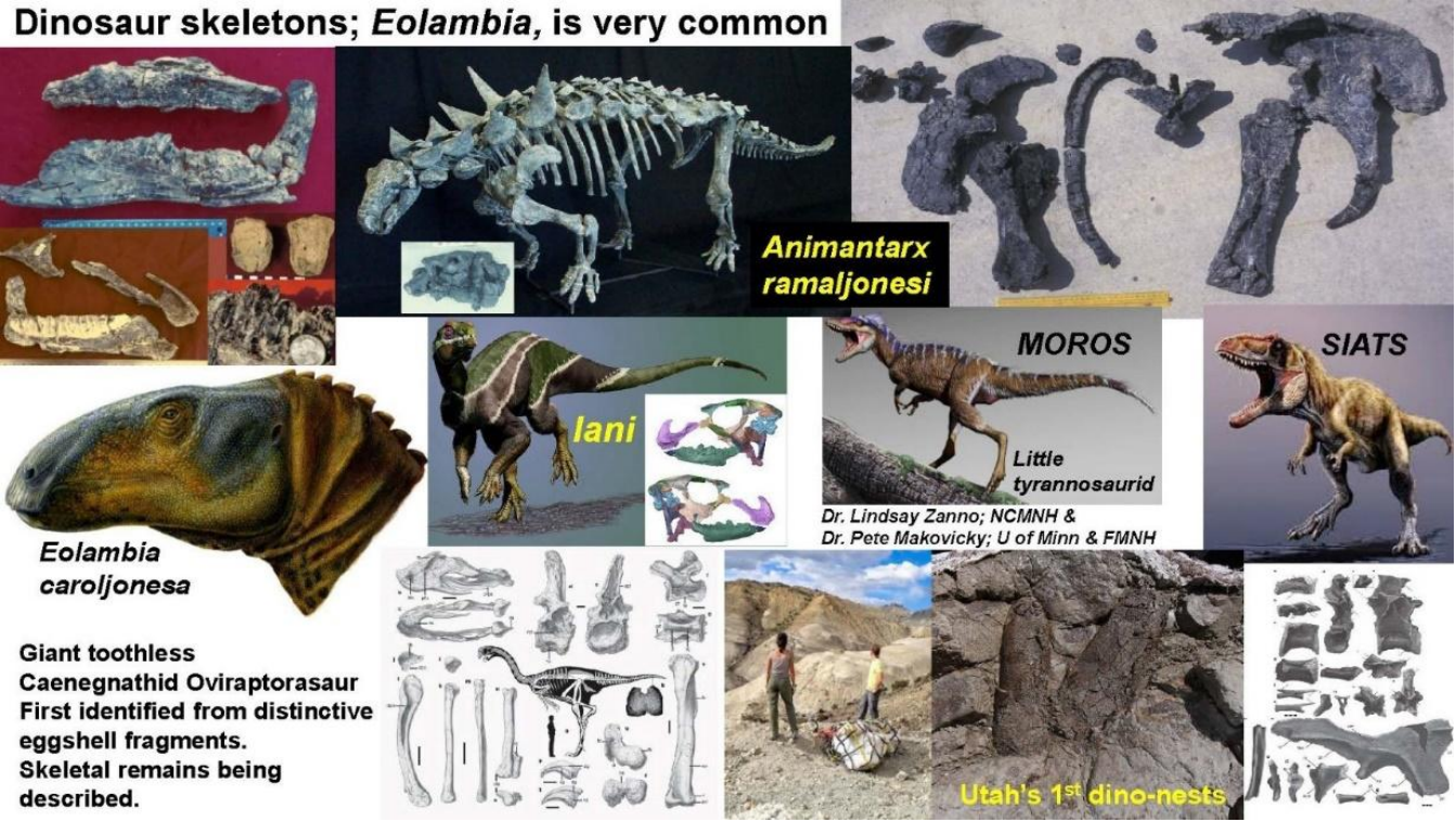
Figure 29. Some examples of dinosaur discoveries in the Mussentuchit Member of the Cedar Mountain Formation on the western side of the San Rafael Swell.
During the late 1990s, the Prehistoric Museum collected many juvenile Eolambia specimens from a single mass mortality site in the Mussentuchit Badlands. Over the last 20 years, Pete Makovicky (of Chicago’s Field Museum) and Lindsay Zanno (of the North Carolina Museum of Natural Sciences) have continued leading teams into the Mussentuchit Badlands each season with extraordinary results (Fig. 31). Although eggshell fragments are fairly common throughout the entire Cedar Mountain, the Zanno team has air lifted out the first large dinosaur nests from the formation. Early tyrannosaurs, the last giant allosauroids, and early horned dinosaurs are among their other groundbreaking discoveries. The outstanding opportunities for hiking trails, and the amazing badlands vistas are obvious additional draws to the area. The north rim of Cathedral Valley is formed by the Last Chance anticline, providing extraordinary views to the south. The Last Chance Road is the gateway to the north end of the Capitol Reef National Park, and where it cuts down through the anticline, it provides a striking cross-section of the south end Jurassic seaway. This road could make an obvious southern extension of SR-10 southward through the Mussentuchit management unit and through Cathedral Valley to SR-24. The development of the Mussentuchit area would provide an impetus to develop the I-70 - SR-10 interchange as the southern gateway up into Castle Valley. Development of this interchange could provide needed infrastructure that does not exist between Green River and Salina (the longest ‘no services’ stretch of interstate in the lower 48 states) and additional jobs for the nearby communities of Emery and Moore. The Museum of the San Rafael in Castle Dale, Utah would provide an essential site for interpretation of the importance of this unique paleontological area. Eventually, the north rim of the Mussentuchit Badlands would be an ideal site for a visitor center, providing an overview of the area and a reason to charge an entry fee to visitors.
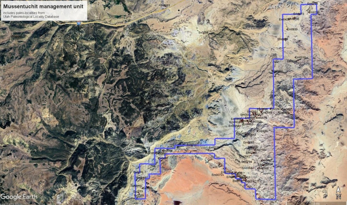
Figure 30. Geographic area of the proposed Mussentuchit unit with paleontological sites from UGS paleo-locality database superimposed.
Conclusions
As the rocks of Emery and Grand counties preserve the most complete record of Lower Cretaceous dinosaurs anywhere in the world, they also offer a unique opportunity to bring economic development to eastern Utah’s underserved rural communities. By centering fossils in the very name, our proposed Dawn of the Cretaceous Fossil Beds National Monument will serve to protect these important paleontological resources, interpret this globally significant area for the public, support ongoing research which contributes to Utah’s prestige, and promote recreation and tourism to boost the region’s economy. In order to be self-sustaining, it will be absolutely essential to focus on infrastructure: visitor centers, restrooms, campgrounds, interpretive signs, and fossil research facilities (foremost among them the repository at Price’s Prehistoric Museum), must be funded and maintained. But with a relatively modest initial investment, this fossil park can be the draw for significant revenue from entrance and lodging fees. In preserving and promoting the region’s extraordinary fossil heritage, Dawn of the Cretaceous Fossil Beds will be a new jewel in the crown of the National Park Service and a boon for the people of Utah.
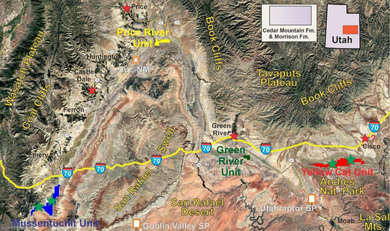
Fig 31. The aerial limits of the four proposed management units with suggested sites for visitor center, camping, hiking trail hubs designated by green stars and community interpretive sites designated by red stars. Red block = Yellow Cat unit. Green block = Green River unit. Yellow block = Price River unit. Blue block = Mussentuchit Unit.
References
Beckham, S.D., with Lentz, F.K., 2000, Rocks & hard places: Historic resources study, John Day Fossil Beds National Monument, Oregon: Seattle, Washington, National Park Service, 253 p. https://www.nps.gov/parkhistory/online_books/joda/hrs/hrs.htm
Cifelli, R.L., Cohen, J.E., and Davis, B.M., 2016, New tribosphenic mammals from the Mussentuchit Local Fauna (Cedar Mountain Formation, Cenomanian), Utah, USA. In Cifelli, R.L and FostowiczFrelik, (eds.) Legacy of the Gobi Desert: Papers in memory of Zofia Kielan−Jaworowska: Palaeontologia Polonica, v. 67, p. 67–81. http://www.palaeontologia.pan.pl/PP67/PP67_calosc.pdf
Cifelli, R.L., Kirkland, J.I., Weil, A., Deinos, A.R., Kowallis, B.J., 1997, High-precision Ar40/Ar39 geochronology and the advent of North America’s Late Cretaceous terrestrial fauna. Proceedings National Academy of Science USA, v. 94, p. 11163-11167.
Clinton, W.A., 1996, Proclamation 6920—Establishment of the Grand Staircase-Escalante National Monument. Administration of William J. Clinton, 1996, Government Printing Office 1788-1791. https://www.govinfo.gov/content/pkg/WCPD-1996-09-23/pdf/WCPD-1996-09-23-Pg1788.pdf
Eaton, J.G. and Cifelli, R.L., 2001, Multituberculate mammals from near the Early-Late Cretaceous boundary, Cedar Mountain Formation, Utah. Acta Palaeontologica Polonica, v. 46, p. 453-518. https://www.app.pan.pl/archive/published/app46/app46-453.pdf
Eaton, J.G., and Kirkland, J.I. 2003. Nonmarine Cretaceous vertebrates of the Western Interior Basin, In Harries, P.J. (eds.) High-Resolution Approaches in Stratigraphic Paleontology; Topics in Geobiology v. 21, Boston. Kluwer Academic Publishers. 263-313.
Foster, J. 2021. Jurassic west—the dinosaurs of the Morrison Formation and their world, 2nd edition. Bloomington, Indiana University Press. 531 p.
Gates, T.A., Sampson, S.D., Zanno, L.E., Roberts, E.M., Eaton, J.G., Nydam, R.L., Hutchison, J.H., Smith, J.A., Loewen, M.A., and Getty, M.A., 2010, Biogeography of terrestrial and freshwater vertebrates from the Late Cretaceous (Campanian) Western Interior of North America.
Palaeogeography, Palaeoclimatology, Palaeoecology, v. 291, p. 371-387. Hunt-Foster, R.K., Kirkland, J.I., and Loewen M.A., editors, 2023, MTE14: 14th Symposium on Mesozoic Terrestrial Ecosystems and Biota. The Anatomical Record. v. 36, Suppl. 1, 267 p. https://drive.google.com/file/d/14Wq4lQZYFqPXpVK6IWHyq3mzCHAsv7us/view
Joeckel, R.M., Suarez, C.A., McLean, N.M., Möller, A., Ludvigson, G.A., Suarez, M.B., Kirkland, J.I., Andrew. J., Kiessling, S., and Hatzell, G.A., 2023, Berriasian–Valanginian Geochronology and Carbon-Isotope Stratigraphy of the Yellow Cat Member, Cedar Mountain Formation, Eastern Utah. USA. In Ludvigson, G.A., Joeckel, R.M., and Suarez, M.B., (eds.), Special Issue: Terrestrial Paleoclimatology and Paleohydrology of the Cretaceous Greenhouse World: MDPI. Geosciences v. 13, 32 p. https://doi.org/10.3390/geosciences13020032
Kirkland. J.I., 2017, Does Utah preserves North America’s oldest Cretaceous dinosaurs because of ancient salt deposits?: Utah Geological Survey, Survey Notes, v. 49, no. 1, p. 4-5. https://ugspub.nr.utah.gov/publications/survey_notes/snt49-1.pdf.
Kirkland. J.I., 2018, Utah’s Early Cretaceous fossils provide critical data on the opening of the Atlantic Ocean: Utah Geological Survey, Survey Notes v. 50, no. 3, p. 6-7. https://geology.utah.gov/mappub/survey-notes/atlantic-fossils/
Kirkland, J.I. and DeBlieux, D.D. 2024, Closing in on the Jurassic-Cretaceous terrestrial faunal boundary in Euramerica: Is the loss of the Morrison "style" dinosaur assemblage linked to a giant shield volcano in the northwest Pacific’s Shatsky Rise, the Morokweng meteor impact in South Africa, or both?; SVP 2024 Program Guide, p. 310-311. https://vertpaleo.org/wpcontent/uploads/2024/10/2024_SVP_Program_Final3.pdf
Kirkland, J.I., DeBlieux, D.D., and Madsen, S.K., 2023, The dawn of the Cretaceous in eastern Utah. In MTE14: 14th Symposium on Mesozoic Terrestrial Ecosystems and Biota. Hunt-Foster, R.K., Kirkland, J.I., and Loewen M.A., (eds.), The Anatomical Record. v. 36, Supplement 1, p. 159-162.
Kirkland, J.I., DeBlieux, D., Hunt-Foster, R., Foster, J., Trujillo, K., and Finzel, E., 2020, The Morrison Formation and its bounding strata on the western side of the Blanding basin, San Juan County, Utah. Geology of the Intermountain West v. 7, p. 137-195. https://giw.utahgeology.org/giw/index.php/GIW/article/view/73
Kirkland, J. I., Suarez, M., Suarez, C., and Hunt-Foster, R., 2016, The Lower Cretaceous in east-central Utah— the Cedar Mountain Formation and its bounding strata: Geology of the Intermountain West, v. 3, p. 101–228. https://giw.utahgeology.org/giw/index.php/GIW/article/view/11/15
Kirkland, J.I., Sertich, J.J.W., and Titus, A.L., 2024, Dinosaur biostratigraphy of the nonmarine Cretaceous of Utah: In Hart, M.B., Batenburg, S.J., Huber, B.T., Thibault, N., Wagreich, M., and Walaszcyzk, I., (eds.), Cretaceous Project 200 Volume 2; Regional Studies, Geological Society of London, Special Publication. v. 545. https://doi.org/10.1144/SP545-2023-211
Ludvigson, G.A., Joeckel, R.M., Gonzalez, L.A., Gulbranson, E.I., Rasbury, E.T., Hunt, G.J., Kirkland, J.I., and Madsen, S.K., 2010, Correlation of Aptian-Albian carbon isotope excursions in continental strata of Cretaceous foreland basin of eastern Utah: Journal of Sedimentary Research, v. 80, p. 955–974.
Ludvigson, G.A., Joeckel, R.M., Murphy, L.R., Stockli, D.F., Gonzalez, L.A., Suarez, C.A., Kirkland, J.I., and Al-Suwaidi, A., 2015, The emerging terrestrial record of Aptian-Albian global change: Cretaceous Research, v. 56, p. 1–24.
Mannion PD. 2024 The spatiotemporal distribution of Mesozoic dinosaur diversity. Biology Letters, v. 20: 20240443. https://doi.org/10.1098/rsbl.2024.0443
McDonald, A.T., Bird, J., Kirkland, J.I., and Dodson, P., 2012, Osteology of the Basal Hadrosauroid Eolambia caroljonesa (Dinosauria: Ornithopoda) from the Cedar Mountain Formation of Utah. PLoS ONE 7(10) e45712. doi:10.1371/journal.pone.0045712
Royo-Torres, R., Upchurch, P., Kirkland, J.I., DeBlieux, D.D., Foster, J.R., Cobos, A., and Alcalá, L., 2017, Descendants of the Jurassic turiasaurs from Iberia found refuge in the Early Cretaceous of western USA: Nature Scientific Reports, v. 7:14311, p. 1-12 DOI:10.1038/s41598-017-14677-2
Sadler, C. 2025, Dinosaur Frontier: Utah at the Dawn of the Cretaceous: Flagstaff, Arizona, This Earth Press, 257 p.
Titus , A., Eaton , J., and Sertich , J. 2016. Late Cretaceous stratigraphy and vertebrate faunas of the Markagunt, Paunsaugunt, and Kaiparowits plateaus, southern Utah. Geology of the Intermountain West, v. 3, p. 229-291., https://doi.org/10.31711/giw.v3.pp229-21
Titus, A.L., and Loewen, M.A., editors, 2013. At the top of the Grand Staircase—the Late Cretaceous of southern Utah: Bloomington, Indiana University Press, 656 p.